SP3 (.sp3)
- Import fully supports the SP3-a and the SP3-c format.
Background & Context
-
- SP3 geospatial file format.
- National Geodetic Survey standard format.
- Stores information about the orbits of GPS satellites.
- SP3 is an acronym derived from Standard Product Version 3.
- ASCII format.
- SP3 was introduced in 1991 by the US National Oceanic and Atmospheric Administration.
Import
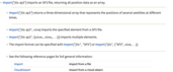
- Import["file.sp3"] imports an SP3 file, returning all position data as an array.
- Import["file.sp3"] returns a three-dimensional array that represents the positions of several satellites at different times.
- Import["file.sp3",elem] imports the specified element from a SP3 file.
- Import["file.sp3",{{elem1,elem2,…}}] imports multiple elements.
- The import format can be specified with Import["file","SP3"] or Import["file",{"SP3",elem,…}].
- See the following reference pages for full general information:
-
Import import from a file CloudImport import from a cloud object ImportString import from a string ImportByteArray import from a byte array
Import Elements
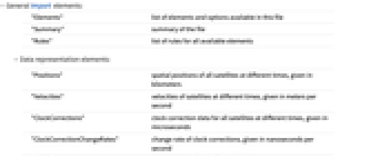
- General Import elements:
-
"Elements" list of elements and options available in this file "Summary" summary of the file "Rules" list of rules for all available elements - Data representation elements:
-
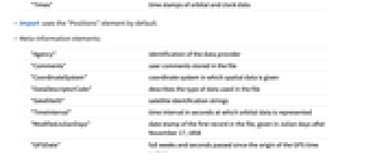
"Positions" spatial positions of all satellites at different times, given in kilometers "Velocities" velocities of satellites at different times, given in meters per second "ClockCorrections" clock correction data for all satellites at different times, given in microseconds "ClockCorrectionChangeRates" change rate of clock corrections, given in nanoseconds per second "Times" time stamps of orbital and clock data - Import uses the "Positions" element by default.
- Meta-information elements:
-
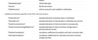
"Agency" identification of the data provider "Comments" user comments stored in the file "CoordinateSystem" coordinate system in which spatial data is given "DataDescriptorCode" describes the type of data used in the file "SatelliteID" satellite identification strings "TimeInterval" time interval in seconds at which orbital data is represented "ModifiedJulianDays" date stamp of the first record in the file, given in Julian days after November 17, 1858 "GPSDate" full weeks and seconds passed since the origin of the GPS time system "OrbitalDataType" orbital data type "Version" file format version "OrbitAccuracy" orbit accuracy for each satellite in millimeters - Additional elements specific to the SP3-c format version:
-
"PositionErrors" standard deviation of position data in millimeters "VelocityErrors" standard deviation of velocity data in millimeters per second "ClockCorrectionErrors" standard deviation of clock corrections in picoseconds "ClockCorrectionChangeRateErrors" standard deviation of clock correction change rates in picoseconds per second "PositionCorrelations" correlation coefficients for position and clock correction data "VelocityCorrelations" correlation coeffiecients for velocities and clock correction change rate data "SatelliteSystems" GPS satellite system "TimeSystem" time reference system used in the file
Examples
Basic Examples (4)
Import and plot the trajectories of all satellites represented in a sample file:
Import and show the trajectory of a single satellite:
Get the list of available Import formats:
Import all position data from the file:
The resulting array represents the spatial positions of 29 satellites at 144 different times:
This shows the orbits of all 29 satellites around the Earth: