CDED
- Import supports the CDED Level 1 standard.
Background & Context

-
- Canadian digital elevation data.
- Standard format for the distribution of terrain elevation data for the United States.
- Canadian Centre for Topographic Information (CTI) standard.
- ASCII format.
- Typically distributed as a ZIP compressed file.
- The .dem file extension is often omitted.
- Stores elevation data as a 1201×1201 raster.
- CDED is available in 1:50,000 and 1:250,000 scales.
- The longitudinal grid spacing varies with the latitude of the geographic area.
- 1:50,000 CDED uses a grid spacing of 0.75×0.75 arc second, 0.75×1.5 arc second, or 0.75×3 arc second.
- 1:250,000 CDED uses a grid spacing of 3×3 arc second, 3×6 arc second, or 3×12 arc second.
- Elevations are expressed in meters relative to mean sea level.
Import
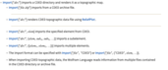
- Import["dir/"] imports a CDED directory and renders it as a topographic map.
- Import["file.zip"] imports from a CDED archive file.
- Import["dir/"] renders CDED topographic data file using ReliefPlot.
- Import["dir/",elem] imports the specified element from CDED.
- Import["dir/",{elem,suba,subb,…}] imports a subelement.
- Import["dir/",{{elem1,elem2,…}}] imports multiple elements.
- The import format can be specified with Import["file", "CDED"] or Import["file",{"CDED",elem,…}].
- When importing CDED topographic data, the Wolfram Language reads information from multiple files contained in the CDED directory or archive file.
- See the following reference pages for full general information:
-
Import import from a file CloudImport import from a cloud object ImportString import from a string ImportByteArray import from a byte array
Import Elements
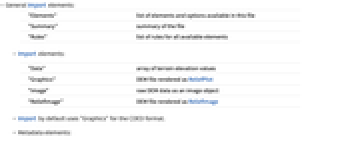

- General Import elements:
-
"Elements" list of elements and options available in this file "Summary" summary of the file "Rules" list of rules for all available elements - Import elements:
-
"Data" array of terrain elevation values "Graphics" DEM file rendered as ReliefPlot "Image" raw DEM data as an image object "ReliefImage" DEM file rendered as ReliefImage - Import by default uses "Graphics" for the CDED format.
- Metadata elements:
-
"Dimensions" size of the elevation data array "ElevationRange" range of elevation coordinates, given in meters "ElevationResolution" resolution of elevation values, given in meters "SpatialRange" range of geographic coordinates, given in decimal degrees "SpatialResolution" grid spacing in arc seconds - Import["file.zip","ElevationRange"] gives the range {zmin,zmax} of elevation values in units of meters.
- Import["file.zip","SpatialRange"] gives the bounding coordinates of the geographic region covered by the file as an expression of the form {{latmin,latmax},{longmin,longmax}}.
- Elements representing the geodetic datum and reference ellipsoid used in the file:
-
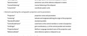
"CoordinateSystem" name of the coordinate system used in the file "Datum" geodetic datum "SemimajorAxis" semimajor axis of the reference ellipsoid in meters "SemiminorAxis" semiminor axis of the reference ellipsoid in meters "InverseFlattening" inverse flattening of the ellipsoid "LinearUnits" coordinate system units - Elements specifying the cartographic projection and its parameters:
-
"Projection" projection name and parameters "Centering" latitude and longitude defining the origin of the projection "StandardParallels" standard parallels "CentralScaleFactor" scale factor at the central meridian or center of projection "GridOrigin" grid coordinates {n,e} of the central parallel and meridian "ProjectionName" Wolfram Language standard name of the projection used "ReferenceModel" what reference sphere or ellipsoid to use - Accessing low-level meta-information from the file:
-
"CoordinateSystemInformation" raw parameters of the coordinate system as stored in the file - See the reference page for GeoProjectionData for full information on cartographic projections.
Options
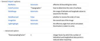
- General Import options:
-
BoxRatios Automatic effective 3D bounding box ratios ColorFunction "Topographic" how to determine the color of surfaces DataRange Automatic the range of latitude and longitude values to assume for the data DataReversed False whether to reverse the order of rows ImageSize Automatic the overall size of the image LightingAngle Automatic the effective angle from which simulated illumination is taken to come - Advanced option:
-
"DownsamplingFactor" 1 integer factor by which the number of latitudinal and longitudinal data points is reduced when importing
Examples
Basic Examples (1)
Import from a CDED directory bundle:
Importing as "ZIP" format shows the files contained in the bundle:
Show the available Import elements: