SDTSDEM (.ddf)
- Import is fully compatible with the SDTSDEM file format.
- Import can also read "SDTS" digital line graph files.
Background & Context
-
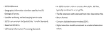
- SDTS GIS format.
- Geographic information standard used by the US Geological Survey.
- Used for archiving and exchanging terrain data.
- SDTS is an acronym for Spatial Data Transfer Standard.
- Based on ISO 8211.
- US Federal Information Processing Standard.
- An SDTS transfer archive consists of multiple .ddf files, typically combined in a .tar.gz file.
- The file extension .ddf is derived from Data Descriptive File.
- Binary format.
- Contains digital elevation models (DEM).
- Digital elevation models are stored as a raster of elevation values.
Import
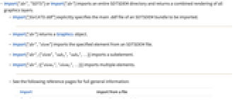
- Import["dir","SDTS"] or Import["dir"] imports an entire SDTSDEM directory and returns a combined rendering of all graphics layers.
- Import["fileCATD.ddf"] explicitly specifies the main .ddf file of an SDTSDEM bundle to be imported.
- Import["dir"] returns a Graphics object.
- Import["dir","elem"] imports the specified element from an SDTSDEM file.
- Import["dir",{"elem","suba","subb",…}] imports a subelement.
- Import["dir",{{"elem1","elem2",…}}] imports multiple elements.
- See the following reference pages for full general information:
-
Import import from a file CloudImport import from a cloud object ImportString import from a string ImportByteArray import from a byte array
Import Elements
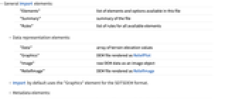
- General Import elements:
-
"Elements" list of elements and options available in this file "Summary" summary of the file "Rules" list of rules for all available elements - Data representation elements:
-
"Data" array of terrain elevation values "Graphics" DEM file rendered as ReliefPlot "Image" raw DEM data as an image object "ReliefImage" DEM file rendered as ReliefImage - Import by default uses the "Graphics" element for the SDTSDEM format.
- Metadata elements:
-
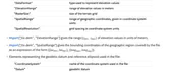
"DataFormat" type used to represent elevation values "ElevationRange" range of elevation values in meters "RasterSize" size of the terrain grid "SpatialRange" range of geographic coordinates, given in coordinate system units "SpatialResolution" grid spacing in coordinate system units - Import["file.dem","ElevationRange"] gives the range {zmin, zmax} of elevation values in units of meters.
- Import["file.dem","SpatialRange"] gives the bounding coordinates of the geographic region covered by the file as an expression of the form {{latmin,latmax},{longmin,longmax}}.
- Elements representing the geodetic datum and reference ellipsoid used in the file:
-
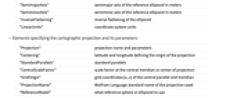
"CoordinateSystem" name of the coordinate system used in the file "Datum" geodetic datum "SemimajorAxis" semimajor axis of the reference ellipsoid in meters "SemiminorAxis" semiminor axis of the reference ellipsoid in meters "InverseFlattening" inverse flattening of the ellipsoid "LinearUnits" coordinate system units - Elements specifying the cartographic projection and its parameters:
-
"Projection" projection name and parameters "Centering" latitude and longitude defining the origin of the projection "StandardParallels" standard parallels "CentralScaleFactor" scale factor at the central meridian or center of projection "GridOrigin" grid coordinates {n,e} of the central parallel and meridian "ProjectionName" Wolfram Language standard name of the projection used "ReferenceModel" what reference sphere or ellipsoid to use - Accessing low-level meta-information from the file:
-
"CoordinateSystemInformation" raw parameters of the coordinate system as stored in the file - See the reference page for GeoProjectionData for full information on cartographic projections.
Options
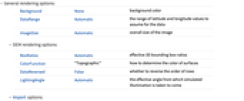
- General rendering options:
-
Background None background color DataRange Automatic the range of latitude and longitude values to assume for the data ImageSize Automatic overall size of the image - DEM rendering options:
-
BoxRatios Automatic effective 3D bounding box ratios ColorFunction "Topographic" how to determine the color of surfaces DataReversed False whether to reverse the order of rows LightingAngle Automatic the effective angle from which simulated illumination is taken to come - Import options:
-
"DefaultElevation" Automatic elevation setting for areas not covered by the file "DownsamplingFactor" 1 integer factor by which the amount of DEM data in each horizontal dimension is reduced on import
Examples
Basic Examples (1)
Import an SDTSDEM digital elevation model:
Get the names of the Import elements available in this file: