TIGER
- Import supports all versions of the TIGER/Line file format.
Background & Context

-
- TIGER/Line GIS file format.
- US Census Bureau file format.
- Used for archiving cartographic information and data.
- Stores geometric as well as numerical and textual information.
- TIGER is an acronym for Topologically Integrated Geographic Encoding and Referencing.
- A TIGER bundle consists of multiple files combined in a file archive or directory.
- ASCII format.
Import
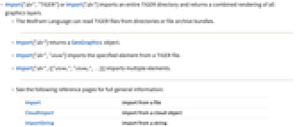
- Import["dir","TIGER"] or Import["dir"] imports an entire TIGER directory and returns a combined rendering of all graphics layers.
- The Wolfram Language can read TIGER files from directories or file archive bundles.
- Import["dir"] returns a GeoGraphics object.
- Import["dir","elem"] imports the specified element from a TIGER file.
- Import["dir",{{"elem1","elem2",…}}] imports multiple elements.
- See the following reference pages for full general information:
-
Import import from a file CloudImport import from a cloud object ImportString import from a string ImportByteArray import from a byte array
Import Elements
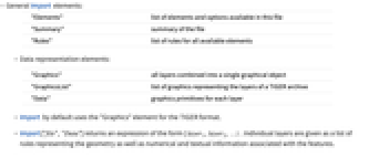
- General Import elements:
-
"Elements" list of elements and options available in this file "Summary" summary of the file "Rules" list of rules for all available elements - Data representation elements:
-
"Graphics" all layers combined into a single graphical object "GraphicsList" list of graphics representing the layers of a TIGER archive "Data" graphics primitives for each layer - Import by default uses the "Graphics" element for the TIGER format.
- Import["file","Data"] returns an expression of the form { layer1,layer2,…} . Individual layers are given as a list of rules representing the geometry as well as numerical and textual information associated with the features.
- Meta-information elements:
-
"LayerNames" all layer names, given as a list of strings "LayerTypes" what graphics primitives comprise each layer "SpatialRange" range of geographic coordinates, typically given in decimal degrees - Elements representing the geodetic datum and reference ellipsoid used in the file:
-
"CoordinateSystem" name of the coordinate system used in the file "Datum" geodetic datum "SemimajorAxis" semimajor axis of the reference ellipsoid in meters "SemiminorAxis" semiminor axis of the reference ellipsoid in meters "InverseFlattening" inverse flattening of the ellipsoid
Options
- General rendering options:
-
GeoBackground Automatic background style ImageSize Automatic overall size of the image