

GeoProjectionData
GeoProjectionData["projection","property"]
gives the value of the specified property for the specified cartographic projection.
GeoProjectionData["projection"]
gives the complete options for the default form of the specified projection.
Details
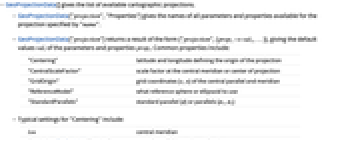
- GeoProjectionData[] gives the list of available cartographic projections.
- GeoProjectionData["projection","Properties"] gives the names of all parameters and properties available for the projection specified by "name".
- GeoProjectionData["projection"] returns a result of the form {"projection",{prop1->val1,… }}, giving the default values vali of the parameters and properties propi. Common properties include:
-
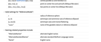
"Centering" latitude and longitude defining the origin of the projection "CentralScaleFactor" scale factor at the central meridian or center of projection "GridOrigin" grid coordinates {e,n} of the central parallel and meridian "ReferenceModel" what reference sphere or ellipsoid to use "StandardParallels" standard parallel {ϕ} or parallels {ϕ1,ϕ2} - Typical settings for "Centering" include:
-
lon central meridian {lat,lon} or GeoPosition[{lat,lon}] central parallel lat and meridian lon {{lat,lon},α} point on center line and azimuth (Oblique Mercator) {{lat1,lon1},{lat2,lon2}} two points on center line (Oblique Mercator) - Valid settings for "ReferenceModel":
-
r radius of reference sphere {a,b} semimajor and semiminor axis of reference ellipsoid {a,{invf}} semimajor axes and inverse flattening "name" name of the geodetic datum or reference ellipsoid - Naming-related properties include:
-
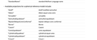
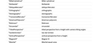
"AlternateNames" alternate English names "AlternateStandardNames" alternate standard Wolfram Language names "Name" English name "StandardName" standard Wolfram Language name - Available projections for a spherical reference model include:
-
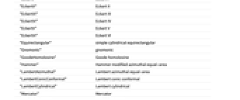
"Aitoff" Aitoff modified azimuthal "Albers" Albers equal-area conic "Armadillo" armadillo "AzimuthalEquidistant" azimuthal equidistant "BipolarObliqueConicConformal" bipolar oblique conic conformal "Bonne" Bonne "Cassini" Cassini "ConicEquidistant" conic equidistant "CylindricalEqualArea" cylindrical equal-area "CylindricalEquidistant" cylindrical equidistant "EckertI" Eckert I "EckertII" Eckert II "EckertIII" Eckert III "EckertIV" Eckert IV "EckertV" Eckert V "EckertVI" Eckert VI "Equirectangular" simple cylindrical equirectangular "Gnomonic" gnomonic "GoodeHomolosine" Goode homolosine "Hammer" Hammer modified azimuthal equal-area "LambertAzimuthal" Lambert azimuthal equal-area "LambertConicConformal" Lambert conic conformal "LambertCylindrical" Lambert cylindrical "Mercator" Mercator "MillerCylindrical" Miller cylindrical "Mollweide" Mollweide "ObliqueMercator" oblique Mercator "Orthographic" orthographic "Stereographic" stereographic "TransverseMercator" transverse Mercator "AmericanPolyconic" American polyconic "Robinson" Robinson "Sinusoidal" sinusoidal "TiltedPerspective" tilted perspective from a height with camera tilting angles "VanDerGrinten" Van der Grinten "VerticalPerspective" vertical perspective from a height "WagnerIX" Wagner IX "Wiechel" Wiechel equal-area "WinkelI" Winkel I "WinkelII" Winkel II "WinkelTripel" Winkel tripel - Available projections for an ellipsoidal reference model include:
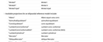
-
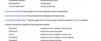
"Albers" Albers equal-area conic "AzimuthalEquidistant" azimuthal equidistant "ConicEquidistant" conic equidistant "LambertConicConformal" Lambert conic conformal "LambertConicConformalNGS" Lambert conic conformal (NGS) "LambertCylindrical" Lambert cylindrical "Mercator" Mercator "ObliqueMercator" oblique Mercator "ObliqueMercatorNGS" oblique Mercator (NGS) "Stereographic" stereographic "TransverseMercator" transverse Mercator - GeoProjectionData["Classes"] gives a list of all supported classes of projections.
- GeoProjectionData["class"] lists all projections belonging to the given class.
- GeoProjectionData["proj","Classes"] gives a list of all the classes of which projection "proj" is a member.
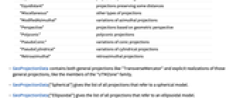
- Classes of projections based on their properties include:
-
"Azimuthal" projections onto a tangent or secant plane "Conformal" projections preserving angles "Conic" projections onto a tangent or secant cone "Cylindrical" projections onto a tangent or secant cylinder "EqualArea" projections preserving areas "Equidistant" projections preserving some distances "Miscellaneous" other types of projections "ModifiedAzimuthal" variations of azimuthal projections "Perspective" projections based on geometric perspective "Polyconic" polyconic projections "PseudoConic" variations of conic projections "PseudoCylindrical" variations of cylindrical projections "Retroazimuthal" retroazimuthal projections - GeoProjectionData contains both general projections like "TransverseMercator" and explicit realizations of those general projections, like the members of the "UTMZone" family.
- GeoProjectionData["Spherical"] gives the list of all projections that refer to a spherical model.
- GeoProjectionData["Ellipsoidal"] gives the list of all projections that refer to an ellipsoidal model.
- GeoProjectionData supports all projections used by the US State Plane Coordinate Systems from 1927 to 1983.
- GeoProjectionData["SPCS27"] and GeoProjectionData["SPCS83"] give the names of all state plane zones.
- GeoProjectionData["UTMZone"] gives names for all UTM zones, both North and South zones.
- GeoProjectionData["UPSZone"] gives the names of the two UPS zones.
- For any state plane, UTM zone, or UPS zone, GeoProjectionData["zone"] gives the name and the standard parameters of the projection used.
- A geo projection proj can be used in GeoGridPosition[pos,proj] or in GeoGraphics[prims,GeoProjection->proj].
Examples
open all close allBasic Examples (4)
Scope (26)
Names and Classes (9)
List of all available cartographic projections:
English name of a cartographic projection:
List of all projections with a spherical reference model:
Projections for the 60 North zones and 60 South zones of the Universal Transverse Mercator coordinate system:
All UTM North zones have the same parameters, except for the centering longitude, which is ![]() for zone
for zone ![]() :
:
The corresponding South zones change the grid origin northing from 0 to 10000 kilometers:
The two Universal Polar Stereographic projections:
They are based on the stereographic projection for an ellipsoidal model:
List of the US State Plane Coordinate Systems of 1927:
Depending on the shape of the states, the coordinate systems are based on these three projections:
Map of respective centering positions:
List of the US State Plane Coordinate Systems of 1983:
They all use the "GRS80" ellipsoid:
Ellipsoidal projections, other than those realized in the "UTMZone", "UPSZone", "SPCS27", and "SPCS83" systems:
Properties and Values (6)
The default parameters of a projection method are generic values, like a sphere of unit radius:
The "Centering" parameter is returned as a GeoPosition object:
Conic projections may have one or two standard parallels, returned as angular Quantity objects:
The "GridOrigin" option gives false easting and northing, frequently used to avoid negative coordinates:
The "Centering" position gets assigned that value, instead of ![]() :
:
The reference model is a numeric object for projections with a spherical reference model:
For cylindrical projections, a value 180/π is used to keep longitude given in degrees:
For ellipsoidal coordinate systems, the reference model is a GeodesyData specification of an ellipsoid:
Types of Projections (11)
Projection Surface (5)
Aspect (3)
Applications (3)
Perform projections of geo locations with GeoGridPosition:
Use projections in GeoGraphics maps, with automatic choice of projection parameters:
Discover the actual parameters chosen for the projection:
Properties & Relations (5)
A general projection typically assumes standard parameters, like a sphere of radius 1:
A realization of that projection assumes explicit values:
In the US State Plane Coordinate System, the ellipsoidal transverse Mercator projection is used for states that are long in the north-south direction:
A Lambert conic conformal projection with ellipsoidal reference frame is used for states that extend in the east-west direction:
The ellipsoidal oblique Mercator projection is used for Alaska:
The Mercator projection is obtained in the cylindrical limit of the Lambert conic conformal projection:
Text
Wolfram Research (2008), GeoProjectionData, Wolfram Language function, https://reference.wolfram.com/language/ref/GeoProjectionData.html (updated 2014).
CMS
Wolfram Language. 2008. "GeoProjectionData." Wolfram Language & System Documentation Center. Wolfram Research. Last Modified 2014. https://reference.wolfram.com/language/ref/GeoProjectionData.html.
APA
Wolfram Language. (2008). GeoProjectionData. Wolfram Language & System Documentation Center. Retrieved from https://reference.wolfram.com/language/ref/GeoProjectionData.html