

GeoVectorENU
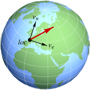
GeoVectorENU[loc{ve,vn}]
represents a horizontal two-dimensional vector of components ve and vn in an orthonormal frame tangent to the Earth at geo location loc.
GeoVectorENU[loc{ve,vn,vu}]
represents a three-dimensional vector of horizontal components ve and vn, and vertical component vu at geo location loc.
GeoVectorENU[{loc1,loc2,…}{vec1,vec2,…}]
represents a collection of vectors veci at respective geo locations loci.
GeoVectorENU[{loc1vec1,loc2vec2,…}]
represents the same collection of vectors.
GeoVectorENU[vec]
represents a geo vector whose associated location has been implicitly specified.
Details
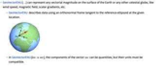
- GeoVectorENU[…] can represent any vectorial magnitude on the surface of the Earth or any other celestial globe, like wind speed, magnetic field, scalar gradients, etc.
- GeoVectorENU describes data using an orthonormal frame tangent to the reference ellipsoid at the given location.
- In GeoVectorENU[locvec], the components of the vector vec can be quantities, but their units must be compatible.
- In GeoVectorENU[locvec], the location loc can be given as a {lat,lon} pair in degrees, a geo Entity object or any geo location object with head GeoPosition or similar.
- GeoVectorENU[GeoVector[…]] converts a vector in GeoVector form to GeoVectorENU form, and similarly for GeoVectorXYZ and GeoGridVector objects.
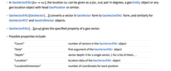
- GeoVectorENU[…][prop] gives the specified property of a geo vector.
- Possible properties include:
-
"Count" number of vectors in the GeoVectorENU object "Data" first argument of the GeoVectorENU object "Depth" vector depth: 0 for a single vector, 1 for a list of them, … "Location" location data of the GeoVectorENU object "LocationDimension" number of coordinates for each position "LocationPackingType" Integer or Real if positions are packed; None otherwise "Vector" vector data of the GeoVectorENU object "VectorDimension" number of components for each vector "VectorPackingType" Integer or Real if vectors are packed; None otherwise
Examples
open all close allBasic Examples (1)
Get a 3D GeoVectorENU object describing the magnetic field at your geo location:
Place a dart with such horizontal direction in a local map of your area and compare with local meridians:
To see the deviation angle, convert to polar GeoVector form:
Show the direction in a world map with a different geo projection, using a smaller dart:
Scope (8)
Data Specification (4)
Specify the location of a horizontal geo vector as a {lat,lon} pair in degrees:
Construct a 3D velocity vector with three identical components at Chicago:
Rewrite the location as a geo position object with any head:
Anything that can be interpreted by GeoPosition can be used as a location:
Work with horizontal 2D or 3D vectors of any unit dimension:
Geo Vector Arrays (3)
Compute gravitational field data simultaneously for several locations:
Convert it to a single geo vector array:
Represent the relative sizes and directions of the small horizontal components:
Generate a million random Cartesian vectors at respective random locations:
Use GeoVectorENU to transform them back to their Cartesian form:
Check that the difference is just numerical error:
Take the locations of the capital cities of the UN countries:
Construct random vectors at those locations:
Properties & Relations (1)
Download information about the geomagnetic field at your current geo location:
Request the information in the form of a GeoVectorENU object:
The original association contains those vector components, with reversed sign in the vertical direction:
Convert the horizontal components of the vector into modulus and declination angle:
Text
Wolfram Research (2019), GeoVectorENU, Wolfram Language function, https://reference.wolfram.com/language/ref/GeoVectorENU.html.
CMS
Wolfram Language. 2019. "GeoVectorENU." Wolfram Language & System Documentation Center. Wolfram Research. https://reference.wolfram.com/language/ref/GeoVectorENU.html.
APA
Wolfram Language. (2019). GeoVectorENU. Wolfram Language & System Documentation Center. Retrieved from https://reference.wolfram.com/language/ref/GeoVectorENU.html