KML (.kml, .kmz)
KML (.kml, .kmz)
Background & Context
-
- KML map data format.
- Standard GIS file format.
- Stores the geometry and data of cartographic map features.
- KML is an acronym for Keyhole Markup Language.
- Used by Google Earth.
- Consists of multiple files combined in a file archive.
- XML format.
- Standard format of the Open Geospatial Consortium.
Import & Export
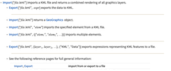
- Import["file.kml"] imports a KML file and returns a combined rendering of all graphics layers.
- Export["file.kml", expr] exports the data to KML.
- Import["file.kml"] returns a GeoGraphics object.
- Import["file.kml","elem"] imports the specified element from a KML file.
- Import["file.kml",{{"elem1","elem2",…}}] imports multiple elements.
- Export["file.kml",{layer1,layer2,…},{"KML","Data"}] exports expressions representing KML features to a file.
- See the following reference pages for full general information:
-
Import, Export import from or export to a file CloudImport, CloudExport import from or export to a cloud object ImportString, ExportString import from or export to a string ImportByteArray, ExportByteArray import from or export to a byte array
Import Elements
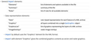
- General Import elements:
-
"Elements" list of elements and options available in this file "Summary" summary of the file "Rules" list of rules for all available elements - Data representation elements:
-
"Data" rule-based representation for each feature of a KML archive "Graphics" all layers combined into a single GeoGraphics object "GraphicsList" list of graphics representing the layers of a KML archive "ImageOverlays" raster image overlays - Import by default uses the "Graphics" element for the KML format.
- Import with element "Graphics" gives the combined graphics contents as vector and raster graphics.
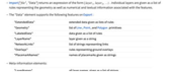
- Import["file","Data"] returns an expression of the form { layer1,layer2,…} . Individual layers are given as a list of rules representing the geometry as well as numerical and textual information associated with the features.
- The "Data" element supports the following features on Export:
-
"ExtendedData" extended data given as lists of rules "Geometry" list of Line, Point, and Polygon primitives "LabeledData" data given as a list of rules "LayerName" layer given as a string "NetworkLinks" list of strings representing links "Overlays" rules representing ground overlays "PlacemarkNames" names of placemarks given as strings - Meta-information elements:
-
"LayerNames" all layer names, given as a list of strings "LayerTypes" what graphics primitives comprise each layer "SpatialRange" range of geographic coordinates, typically given in decimal degrees - Geographic coordinates in KML files always refer to the WGS84 datum.
Options
- General rendering options:
-
Background None background color ImageSize Automatic overall size of the image