GeoGridRangePadding


GeoGridRangePadding
is an option for geographic functions that specifies how much to extend the projected coordinate ranges determined by GeoGridRange.
Details
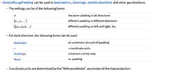
- GeoGridRangePadding can be used in GeoGraphics, GeoImage, GeoElevationData and other geo functions.
- The settings can be of the following forms:
-
p the same padding in all directions {px,py,…} different padding in different directions {{pxL,pxR},…} different padding on left and right, etc. - For each direction, the following forms can be used:
-
Automatic an automatic amount of padding s s coordinate units Scaled[s] a fraction s of the map None no padding - Coordinate units are determined by the "ReferenceModel" parameter of the map projection.
Examples
open all close allScope (2)
Properties & Relations (1)
GeoRangePadding adds padding before projection:
GeoGridRangePadding adds padding after projection:
Wolfram Research (2019), GeoGridRangePadding, Wolfram Language function, https://reference.wolfram.com/language/ref/GeoGridRangePadding.html.
Text
Wolfram Research (2019), GeoGridRangePadding, Wolfram Language function, https://reference.wolfram.com/language/ref/GeoGridRangePadding.html.
CMS
Wolfram Language. 2019. "GeoGridRangePadding." Wolfram Language & System Documentation Center. Wolfram Research. https://reference.wolfram.com/language/ref/GeoGridRangePadding.html.
APA
Wolfram Language. (2019). GeoGridRangePadding. Wolfram Language & System Documentation Center. Retrieved from https://reference.wolfram.com/language/ref/GeoGridRangePadding.html