

GeoRangePadding
is an option for GeoGraphics that specifies what padding to use when extending beyond the original ranges of latitude and longitude.
Details
- The settings can be of the following forms:
-
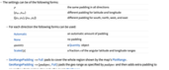
p the same padding in all directions {plat,plon} different padding for latitude and longitude {{pS,pN},{pW,pE}} different padding for south, north, west, and east - For each direction the following forms can be used:
-
Automatic an automatic amount of padding None no padding quantity a Quantity object Scaled[s] a fraction  of the angular latitude and longitude ranges
 - GeoRangePadding->Full pads to cover the whole region shown by the map's PlotRange. GeoRangePadding->{padspec,Full} pads the geo range as specified by padspec and then adds extra padding to cover the whole region shown by the map's PlotRange.
- GeoRangePadding can take Quantity angles and lengths. Angles are interpreted as directly extending the angular geo range, while lengths are used as radii for geo disks around the corners of the geo range. Raw numbers are taken to be lengths in meters.
- GeoRangePadding extends GeoRange before projection.
Examples
open all close allBasic Examples (3)
By default, some padding is added around objects in maps:
Use GeoRangePaddingNone to remove padding:
Use GeoRangePadding{…,Full} to complete a rectangular map:
Use 50 kilometers of padding on each side of the map:
Specify padding for latitude only:
Scope (4)
By default, there is automatic padding of the geo background:
Restrict to the given geo range:
Padding can be specified as a Quantity angle, extending the original latitude and longitude ranges:
Or as a Quantity length:
Raw numbers are interpreted as distances in meters:
Specify padding as a fraction of the original geo range:
Properties & Relations (3)
Construct the corners of a geo range:
Extend to a new geo range by adding geo disks of a given radius at those corners:
Visualize the original and padded geo rectangles:
Compare the region covered by the original and padded geo rectangles:
The padded geo rectangle corresponds to the original one with given padding:
GeoRangePadding adds padding before projection:
GeoGridRangePadding adds padding after projection:
An angle specification of padding extends the angular geo ranges:
It is equivalent to a direct extension of the geo range in each direction:
Text
Wolfram Research (2014), GeoRangePadding, Wolfram Language function, https://reference.wolfram.com/language/ref/GeoRangePadding.html.
CMS
Wolfram Language. 2014. "GeoRangePadding." Wolfram Language & System Documentation Center. Wolfram Research. https://reference.wolfram.com/language/ref/GeoRangePadding.html.
APA
Wolfram Language. (2014). GeoRangePadding. Wolfram Language & System Documentation Center. Retrieved from https://reference.wolfram.com/language/ref/GeoRangePadding.html